A construction site is an extraordinarily complex and dynamic environment. With half-completed structures, cranes, lifts, ladders, scaffolding, stacked materials, and busy workers moving around trying to meet demanding deadlines, keeping track of what is going on can be a daunting task.
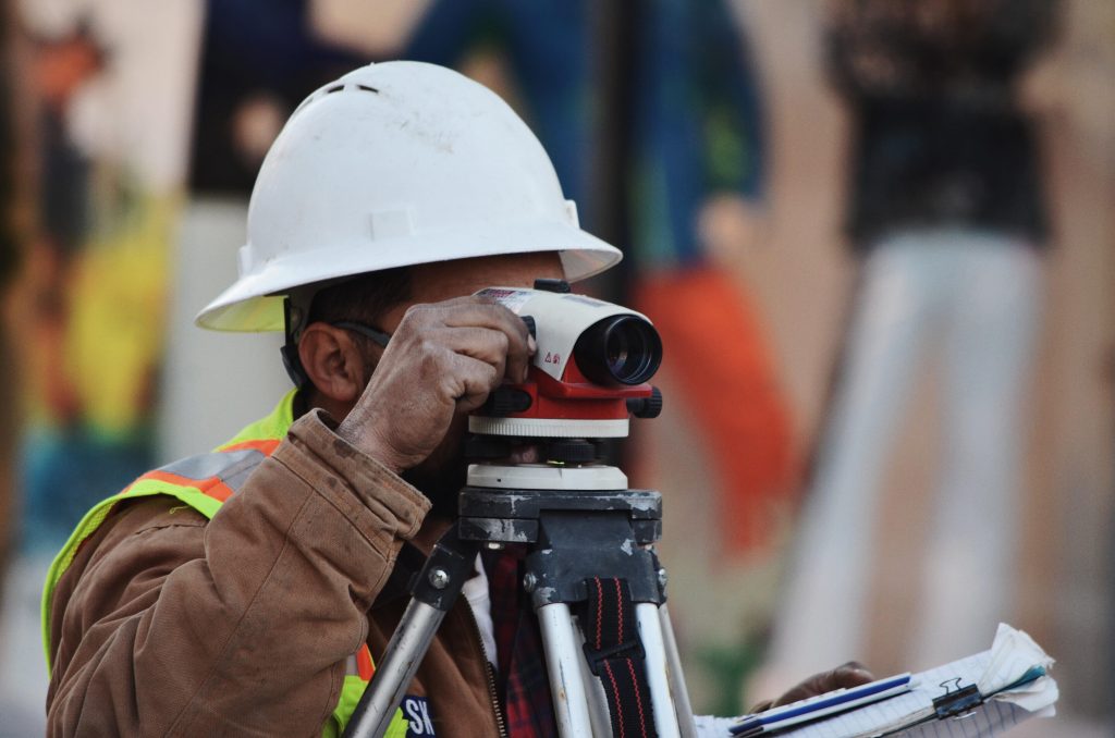
While architects can produce highly accurate 3D models with computer-aided design (CAD), construction is largely still a manual process. Works inspection depends on a skilled surveyors’ eyes to determine whether an element is within the acceptance range defined by the project manager. Our previous article mentioned the scenario where the general contractor wanted to check if all the ducts in the ceiling were installed above 2 meters as specified by the plans, and checked this by using a 2-meter-tall stick, walking around, and stopping when it hit something lower than the 2-meter mark. Situations like these are considered normal in construction and, to put things into a bigger perspective, only 5%-10% of works ultimately are checked.
These circumstances show us there is a deep fault line in the traditional construction industry. We can recognize the indicators of an outdated system, but what is the actual root cause? To answer this question, we need to understand how construction operates to find what is wrong with the current quality control systems.
Unlike traditional manufacturing, where the components move through the manufacturing plant, the plant moves through and around the components in construction. Elements are becoming installed at different rates, and this inherent characteristic requires different frequencies of data capture. Manual data verification and quality control alone is insufficient and error-prone. On the one hand, these methods are so time-consuming that they find themselves largely un-scalable when we consider square meters and thousands of elements on-site to be hundreds inspected. On the other hand, it is unreasonable to occupy and rely solely on someone’s professional experience to perform such complex jobs, when this person could focus instead on tasks that genuinely add value to the business.
While we may design digitally, we still construct manually, and this disconnection between the digital and the physical world is at the core of the industry’s inefficiencies. The site’s progress monitoring and quality control is a highly complex process, but a push for automation within the field could change that.
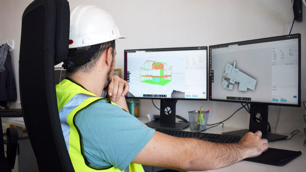
Like the industry switched from hand drawing to electronic drawing with CAD, and the latter provided a stepping stone for a more comprehensive tool referred to as BIM or Building Information Modeling; it is time to open the way for new technologies. Scaled Robotics’ goal is to provide the industry with a new set of tools to monitor progress accurately and measure quality on the construction site. By comparing the area under construction against the BIM model, we offer our customers actionable information in near real-time, helping them localize and correct errors before they have costly downstream effects.
Here is where the concept of structured data comes in. As mentioned before, construction sites are complex environments, so it becomes necessary to go out into the field and drag that cluttered data back into the different BIM workflows. In this way, the information gathered on execution and build-ability allows for enhanced transparency within project delivery. It offers a unique opportunity to catch issues in good time, learn from them, and avoid repeating them. It is also an intelligent process that feeds back into the design stage.
At the moment, the most detailed and accurate systems for the capturing of 3D data are terrestrial laser scanners. They produce a collection of data points, also known as point clouds. The create a complete picture of the area. Laser 3D points can be mathematically connected to scanning, changing construction in ways never seen before. It provides immediate information to the construction teams, improving accuracy and quality, saving costs, and reducing efforts. This makes the overall construction process more efficient.
As the popularity of 3D scanners in the industry has accelerated, so too has the proliferation of scanner types and brands. Well-known brands include Leica, Faro Focus, Zoller, and Trimble. Some of their scanners capture fewer point clouds per second (pps), while others a higher point density. Some can produce precise high-quality scans that are rich in detail but at the cost oflonger scanning times. Conversely, other types of scanners are faster, but they trade speed for accuracy. There are multiple options as they relate to different factors inherent to construction, such as acquisition rate, data resolution/accuracy, and acquisition distance. There is no one ideal method for use in monitoring, as each has both strengths and weaknesses.
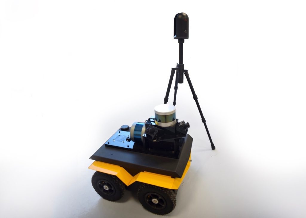
Scaled Robotics’s robot moves us a step forward towards fully automating progress monitoring and quality control process. Our low-to-the-ground four-wheeled machine is fitted with a 3D Laser Scanner (LIDAR), RGBD cameras, and other sensors that allow it to make detailed 3D surveys and panoramic photos of the construction site. The robot can be either remote-controlled or programmed to move autonomously around the construction site due to its use of Simultaneous Localization and Mapping (SLAM) technology. It can be used at regular intervals or as often as needed, and there is no limit to the square meters it can cover.
Surely it is a pretty cool tool, but, at the end of the day, it is just one of the many means that our customers can use to collect data. Our web-based analysis software is focused on providing actionable information to our users; thus, it is agnostic to the reality capture device used. This means that our clients may use any terrestrial laser scanners existing in the market to scan their site, such as the Leica RTC360. Regardless of the source, we can process their raw data and produce high-quality analysis, ensuring the same customer experience.
As soon as the collection of data is finished and the model is complete, the information is uploaded to the cloud, where we provide a holistic solution by leveraging the state of the art in Computer Vision, Machine Learning, and Artificial Intelligence. It is a fine-grained analysis that radically reduces risk and uncertainty on project delivery.
Curious about the process? Read our next article to learn more details about the way the raw data becomes processed and visualized.